Ireland is an island in Northwestern Europe in the north Atlantic Ocean. The island lies on the European continental shelf, part of the Eurasian Plate. The island's main geographical features include low central plains surrounded by coastal mountains. The highest peak is Carrauntoohil (Irish: Corrán Tuathail), which is 1,041 metres (3,415 ft) above sea level. The western coastline is rugged, with many islands, peninsulas, headlands and bays. The island is bisected by the River Shannon, which at 360.5 km (224 mi) with a 102.1 km (63 mi) estuary is the longest river in Ireland and flows south from County Cavan in Ulster to meet the Atlantic just south of Limerick. There are a number of sizeable lakes along Ireland's rivers, of which Lough Neagh is the largest.
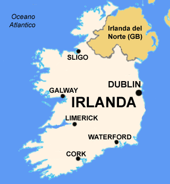
Politically, the island consists of the Republic of Ireland, with jurisdiction over about five-sixths of the island; and Northern Ireland, a constituent country(and an unconfirmed "practical" exclave) of the United Kingdom, with jurisdiction over the remaining sixth. Located west of the island of Great Britain, it is located at approximately 53°N 8°WCoordinates: 53°N 8°W. It has a total area of 84,421 km2 (32,595 sq mi).[1] It is separated from Great Britain by the Irish Sea and from mainland Europe by the Celtic Sea. Ireland and Great Britain, together with nearby islands, are known collectively as the British Isles; as the term British Isles is controversial in relation to Ireland, the alternative term 'Britain and Ireland' is increasingly preferred.


Malin Head is the most northerly point in Ireland, while Mizen Head is one of the most southern points, hence the term "Malin head to Mizen head" (or the reverse) is used for anything applying to the island of Ireland as a whole. Carnsore Point is another extreme point of Ireland, being the southeastern most point of Ireland. Further along the coast is Hook Head while the Old Head of Kinsale is one of many headlands along the south coast of Ireland.
Loop Head is the headland at which County Clare comes to a point on the west coast of Ireland, with the Atlantic on the north, and further inland on the south, the Shannon estuary. Hag's Head is another headland further up Clare's north/western coastline, with the Cliffs of Moher along the coastline north of the point.
Erris Head is the northwesternmost point of Connacht.

No hay comentarios:
Publicar un comentario